Methodology: Basic principles of archaeological stratigraphy
Published: April 29, 2020

Methodology: Basic principles of archaeological stratigraphy
We have referred to the concept of the stratigraphic sequence in many of our recent posts. It is one of the methodological pillars of archaeology and we will briefly explain this today.
Archaeological stratigraphy is the study of the order in which soil or other layers were deposited, and in which cut features (such as pits) or built structures (like walls) were created.
As the elements of stratigraphy include not only soil layers, but built structures and the excavation cuts for negative features such as pits or ditches, we refer to them as contexts. Sometimes these are also called stratigraphic units. Contexts can be man-made or created by natural events or erosion, such as hillwash or sediments deposited by flooding. Each context is usually given a number, and that is then used to create a ‘matrix’ – essentially a flow chart which shows the order in which each of the identified contexts occurred.
The relative position of a layer or feature, and the type and nature of any archaeological remains found within it, establish its age. For example a layer located above one containing only 15th-century artefacts and construction techniques but below one with 16th-century finds, would clearly fit somewhere between these two centuries. Normally the latest find in a context is used to date it, as later layers often contain material disturbed from earlier ones.
In order to interpret a stratigraphy, there are several things to keep in mind. Layers are usually deposited horizontally, subject to the topography of the land. If there has been no subsequent human alteration of the site, the upper levels will be more recent than the ones below. Where there are breaks in the horizontal layers, there has been human or natural alteration of the stratigraphy – by excavation or erosion.
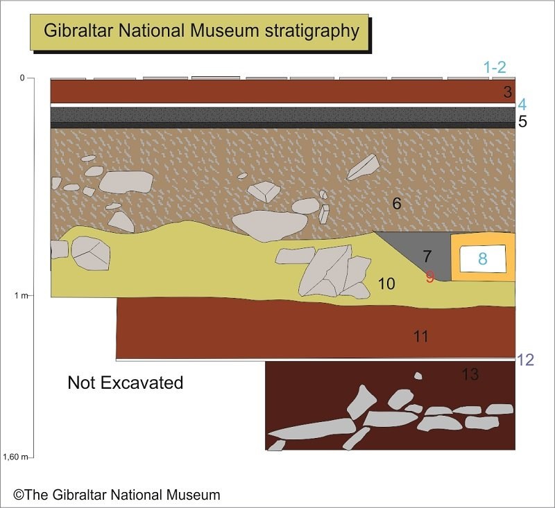
We will use a sequence from an archaeological survey carried out at the Gibraltar National Museum as an example. The numbers in blue, are the built contexts, in black the deposited layers and in red are cuts or excavated negative contexts.
Contexts1 & 2: Cement and tiled floor from the 20th century
Context 3: Red sand floor, later 19th or 20th century
Context 4: Lime mortar paving from the 18th-19th centuries
Context 5: Level of ash and charcoal relating to a fire during the Great Siege of Gibraltar (1779-83)
Context 6: Brown clays and limestone with 17th century archaeological materials
Context 7: Sand and clay backfill of the trench, 9, for a water channel
Context 8: 16th-17th-century brick water channel leading to a cistern in the centre of the house
Context 9: Cut of a trench for a water channel
Context 10: Layer of light brown clays with ceramic remains from the 16th century
Context 11: Clay, red sand and lime infill with Medieval Islamic materials from the 14th-15th centuries
Context 12: Compacted lime paving from the 14th-15th centuries
Context 13: Red sand and clay with limestone blocks and materials from the 14th-15th centuries
Other similar VM - Archaeology
18-20 Bomb House Lane
PO Box 939,
Gibraltar
