In Search of the Tarfes
Published: April 15, 2020

Islamic medieval line wall
In Search of the Tarfes
The chronicles from authors in modern history, such as Hernández del Portillo, Barrantes Maldonado or López de Ayala, describe a series of place names in the southernmost area of Gibraltar’s peninsula that clearly refer to constructions dating from the Islamic medieval period.
The place named ‘Los Tarfes’, has a clear etymology in the Arabic term ‘al-tarf’ meaning an end, limit, border, edge or shore. López de Ayala’s descriptions divide the area into two, the lower and upper Tarfes. Based on his descriptions we can locate the lower Tarfes in the area once known as ‘La Caleta del Laudero’ (Little Bay) and from the area around the Shrine of Our Lady of Europe to the plateau of Europa Point. The upper Tarfes could have been at Windmill Hill Flats, where the ‘Torre de los Genoveses’ (Genoese Tower) was located.
Archaeological remains can sometimes be elusive and confirming the location of the Tarfes through archaeology has not been easy. However, thanks to archaeological watching briefs in the area carried out as part of new construction projects, we are beginning to see indications of these old place names.
Archaeological excavations carried out in 1990s in the area of Nuns’ Well, a cistern of possible Islamic origin, or in the vicinity of the Shrine of Our Lady of Europe, had not detected any remains from the medieval period.
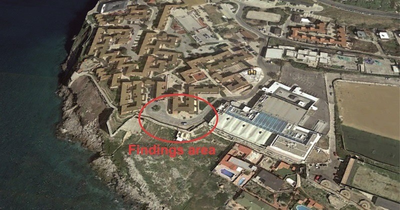
Last year, whilst electrical infrastructure works were being carried out in the area, our archaeologists were finally able to detect a series of remains pertaining to this period, a line wall and an assemblage of ceramics clearly attributed to the 14th and 15th centuries when the Marinid and Nasrid dynasties ruled the city of Gibraltar.
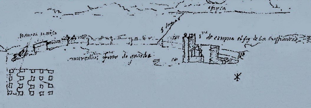
The wall was in context with these ceramics so there was no doubt as to its date, confirmed by its construction in masonry using small and large stones. This could be part of the line wall portrayed by Anton van den Wyngaerde in his 1567 sketches of Gibraltar. The ceramics consist of a set of ‘ataifores’ (conical plates), pots, pans, bottles and jars with clear characteristics of this time. An archaeological watching brief was also carried out as part of the construction of the new sporting facilities at Windmill Hill Flats, although no remains from this period were detected here.
There is still much to learn about the urban development of these areas of Gibraltar, far from the main city, but thanks to these archaeological watching briefs we now have physical evidence of their existence and location. These will surely be expanded as part of future projects in this part of Gibraltar.

Anton van den Wyngaerde's annotated sketches showing the area of Europa Point. He depicts the Shrine of Our Lady of Europe and the defensive line wall.
Medieval ceramic cooking pot from the Marinid/Nasrid Islamic period of the 14th/15th century.
Medieval ceramic bottle from the Marinid/Nasrid Islamic period of the 14th/15th century.

Area of Europa Point where the medieval wall and ceramics were found.
Other similar VM - Archaeology
18-20 Bomb House Lane
PO Box 939,
Gibraltar
