Fortifications South Bastion
Published: December 08, 2020
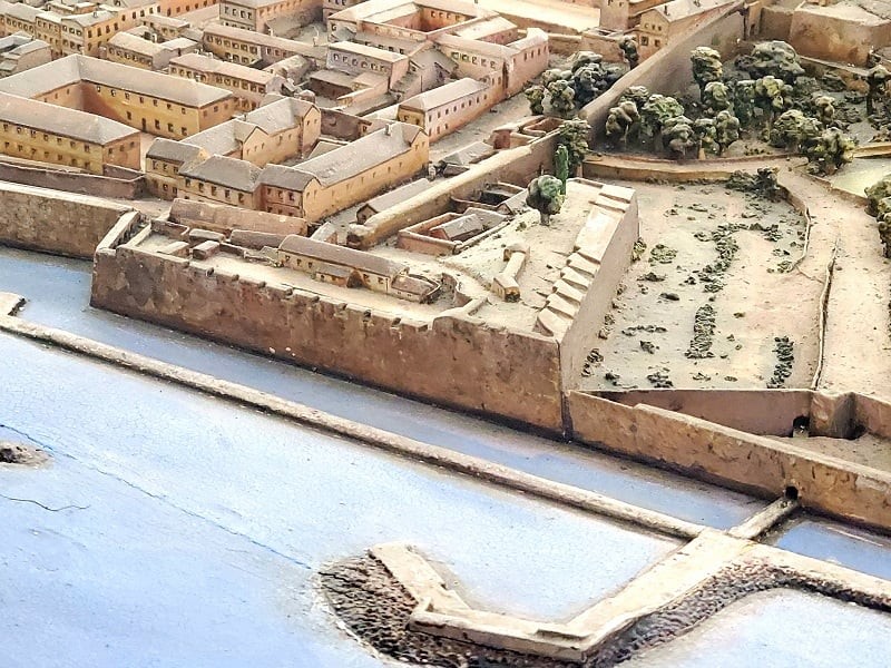
A view of South Bastion on the 1865 scale model of Gibraltar.
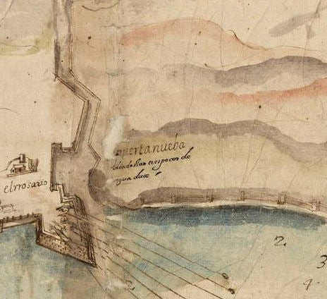
Section of the 1608 plan of Gibrlatar by Cristobal de Rojas showing South Bastion (Baluarte de Nuestra Señora del Rosario), Charles V Wall (Muro de Carlos V) and Flat Bastion (Baluarte de Santiago).
Fortifications South Bastion
South Bastion, or Baluarte de Nuestra Señora del Rosario, named after the hermitage of Our Lady of the Rosary as called by the Spanish, was built at around 1540 and it lies to the north of Ragged Staff Gate. South Bastion was 300ft long on the sea face and 260ft long on the southern side. The parapet was 18ft thick with a wall 3ft high and 2ft thick. This wall is higher than the Line Wall in order to cover the town from the higher ground of the red sands, now the Alameda Botanic Gardens. The walls were made with large sun-dried bricks and so got washed away throughout the years by the rain. This wouldn’t have happened if a coating of Tapia, a mixture of sand and lime had been applied from time to time.
The bastion was originally designed by Bendetto Da Ravena in 1540 under Emperor Charles V and was left unfinished. Following the Anglo-Dutch capture of Gibraltar in 1704, the British entirely neglected the bastion until 1757, when Lord Tyrawley, General O’Hara’s father, strengthened the southern face of the bastion, as this was the weakest point. Before this, the guns on the southern face were placed behind 12 embrasures.
A plan of 1826 shows two casemated embrasures, almost at ground level, and still visible today, pointing east and covering Southport, 2 embrasures on the eastern end of the south face and 5 on the western end, 10 on the right face and 2 on the right flank and platforms for 2 howitzers. In 1870 the bastion was reconstructed to take 3 10” RML guns in Gibraltar Shields (iron shielded casemates). The main magazine of the bastion was placed at the rear of the bastion (today’s Hall of Fame restaurant). On top of the concrete work, (just to the south of what is today the Gibraltar College) is a circular position. This was the Sound Locator emplacement for the Ragged Staff Anti-Aircraft Search Light position used in the Second World War.
With time, as artillery developed and increased in range many of these coastal bastions were no longer required for defence purposes. Gibraltar’s fortifications today however, continue to be impressive historical monuments, many of which have been sensitively restored and given new uses that are compatible with our modern living.
Other similar Virtual Museum
Virtual Museum VM - Historical Notes from our Archive
historical notes from our archive a. e. serfaty
Published: April 04, 2020
Virtual Museum VM - Historical Notes from our Archive
Historical Notes from our Archive The Paint Supply Co.
Published: April 16, 2020
Virtual Museum VM - Historical Notes from our Archive
Historical Notes from our Archive The Rock Hotel
Published: April 20, 2020
18-20 Bomb House Lane
PO Box 939,
Gibraltar